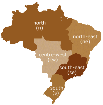
Brazil is divided politically and geographically into five different regions which share common features in relation to their physical, human, economic and cultural aspects. The borders of each region – North, North-East, South-East, South and Centre-West coincide with the borders of the states which they comprise.
The North region covers the major part of the Brazilian territory, with an area that corresponds with 45.27% of the 8,547,403.5 km2 that makes up the total area of Brazil. Comprising seven states, its area is almost completely dominated by the Amazon River basin. The North-East region may be considered as being the most heterogeneous in the country. Divided into four vast areas – mid-north, forest area, wild lands and backlands – it occupies 18.26% of the Brazilian territory and comprises nine states.
The South-East, Brazil’s most important region from an economic point of view, also contains the highest concentration of population – 42.63% of Brazil’s total population of 157,079,573 – and industrial production. It is made up of four states and presents major differences in relation to its physical aspect, with a coastal strip, mountains and plains.
The South, Brazil’s coldest region which undergoes periods of frost and snow, is the smallest region, occupying 6.75% of the Brazilian territory and comprising just three states. The rivers flowing through this area form almost the entire Paraná Basin and are of great national importance, chiefly because of their hydroelectric potential.
Lastly, the Centre-West region is basically dominated by the Central Brazilian Plateau and may be divided into three portions: Goiano-Mato Grosso Massif, Paraná sedimentation basin and the depressions. Comprising four states, this region has been undergoing significant changes in relation to its vegetation with the cerrado (scrubland) being gradually replaced by plantations or cattle-rearing as a result of the process of occupation that has taken place in this part of Brazil.